Unit on Climate Change,Research and Development Initiative, Chuo University

GOSAT Validation in Mongolia

PROJECT OVERVIEW

Advancement of Satellite-Based Greenhouse Gas Emissions Estimation Technology Targeting Mongolia

Introduction

The Ministry of the Environment, in line with the Basic Space Plan, is advancing the GOSAT, GOSAT-2, and their successor, GOSAT-GW projects, in collaboration with the Japan Aerospace Exploration Agency (JAXA) and the National Institute for Environmental Studies (NIES). These projects are aimed at measuring concentrations of key greenhouse gases, such as carbon dioxide and methane, from space to continuously contribute to the development of science related to climate change and support international climate change policies.

International Trends

At the 49th session of the Intergovernmental Panel on Climate Change (IPCC), the “2006 IPCC Guidelines for National Greenhouse Gas Inventories” were revised to incorporate the use of satellite data for the first time, highlighting expectations for improved accuracy in reporting emissions from countries using GOSAT and GOSAT-2. Countries are obligated under the Paris Agreement to report their greenhouse gas emissions and absorptions. Japan promotes the use of data observed by the GOSAT series, including GOSAT, GOSAT-2, and the successor GOSAT-GW (currently under development for launch in fiscal year 2023), to enhance transparency in reporting and encourage countries to evaluate their reports.

So Far

With the cooperation of the Mongolian government, the Ministry of the Environment has conducted objective accuracy verification of GOSAT over approximately 28 months from December 2018 to March 2021. This involved comparing CO2 emissions recorded in the greenhouse gas inventory for Mongolia with estimates derived from GOSAT observation data across the entire country, including Ulaanbaatar and its vast grasslands, obtaining initial results that substantiate the effectiveness and reliability of GOSAT. Mongolia, a non-Annex I country, is not obligated to submit National Inventory Reports (NIR) and Common Reporting Format (CRF) tables like Annex I countries but plans to publish its GHG inventory as part of its national communications and Biennial Update Reports (BUR).

Project Objective

Building on the evaluation results of CO2 emissions by GOSAT from the previous fiscal year, this project aims to further improve accuracy with GOSAT-2 and enhance practicality by comparing and evaluating methane (CH4) emissions estimated using GOSAT and GOSAT-2 observation data against inventory emissions.

Evaluation of CO2 and CH4 Emission Estimation Accuracy in Ulaanbaatar City and Mongolia

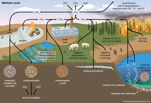
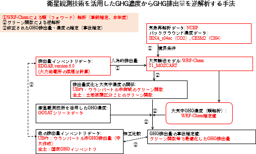
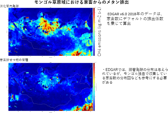
In fiscal year 2021, we constructed an atmospheric transport model utilizing the nationwide CO2 and CH4 inventory of Ulaanbaatar city and Mongolia established in the same year. This model allowed us to calculate preliminary estimates of CO2 and CH4 emissions and concentrations across Mongolia.

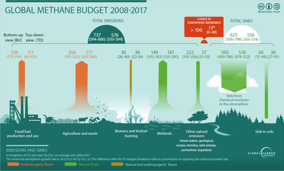
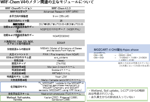
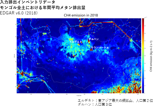
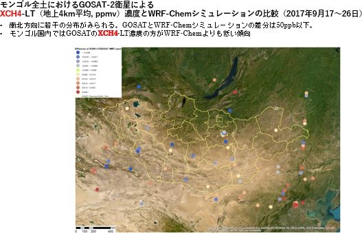
For the entire territory of Mongolia and the city of Ulaanbaatar, we conducted forward analysis for CO2 and CH4 using the regional chemical transport model (WRF-Chem). We utilized The Emissions Database for Global Atmospheric Research version 6.0 (EDGARv6.0) as the a priori emission amount, JENA_s04oc (provided by the Max-Planck Institute) for CO2, and the Community Earth System Model 2 (CESM2) for CH4 as boundary conditions.

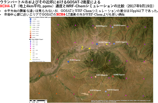
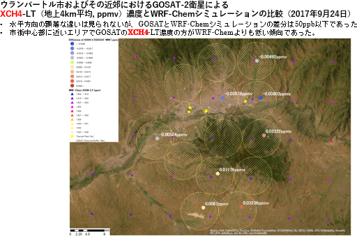
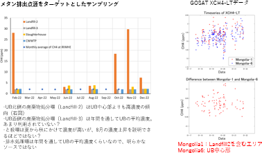
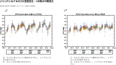
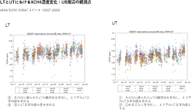
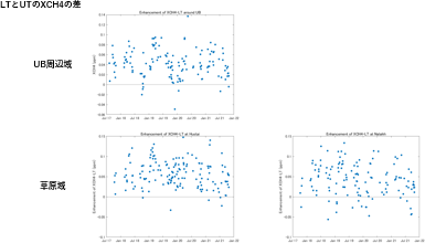
The forward analysis results for CH4 showed that the difference between XCH4-LT (column-averaged CH4 concentration at about 4km above ground) concentrations from GOSAT observations and WRF-Chem simulations was within approximately 50 ppb. Generally, GOSAT showed lower CH4 concentrations within the territory of Mongolia.

Given that the standard deviation for CH4 against the Total Carbon Column Observing Network (TCCON) for GOSAT-1 is 11.24 ppb, it is expected that this level of difference can be sufficiently detected when conducting inverse analysis for CH4 emissions.


Ground Observation for Evaluation of CO2 and CH4 Emission Estimation Accuracy

Continuing the GHG ground observations in urban and grassland areas from fiscal year 2021, we appropriately procured and managed consumables needed for maintenance and calibration of the measuring equipment.

With the cooperation of the Institute of Meteorology and Hydrology Research (IRIMHE), we conducted measurements of CO2 and CH4 concentrations in Ulaanbaatar city and its suburbs. The measurements indicated an annual increase in methane concentrations, with higher concentrations in winter and significant levels around waste disposal sites. In grassland areas, the trend showed higher XCH4 concentrations at lower troposphere (LT) than in the upper troposphere (UT), suggesting that inverse analysis using LT could be effective.

Support for Information Disclosure

Under coordination and information sharing with the Ministry of the Environment officials, we supported information disclosure and public relations activities related to environmental administration both domestically and internationally. Specifically, we participated online in the 18th International Workshop on Greenhouse Gas Measurements from Space (IWGGMS-18) and the 19th Workshop on Greenhouse Gas Inventories in Asia (WGIA19), presenting posters and oral presentations.

Mongolia plans to include, as a Best Practice in Chapter 3 of the 2nd Biennial Update Report (BUR2) to the UNFCCC this fiscal year, the world’s first account of CO2 emissions using satellite observation data. This result is under the collaboration between IRIMHE and Chuo University, with Chuo University drafting the chapter description for Mongolia’s Climate Change Research and Cooperation Center (CCRCC) to compile. A specific proposal for this chapter was made to Dr. Zamba Batjargal of CCCRCC, and mutual agreement was reached. As Best Practice will also be adopted in BTR, it confirms Mongolia’s intention to continue advancing emission estimation using satellite data.

Main Results

  1. Across the entirety of Mongolia and the entire city of Ulaanbaatar, forward analysis for CO2 and CH4 was conducted using the WRF-Chem with EDGARv6.0 as the a priori emission amount, JENA_s04oc (provided by Max-Planck Institute) for CO2, and CESM2 for CH4 as boundary conditions. The forward analysis results for CH4 showed that the difference between the XCH4-LT (column-averaged CH4 concentration at approximately 4km above the surface) concentrations from GOSAT observations and WRF-Chem simulations was within approximately 50 ppb. Generally, within the targeted area, GOSAT concentrations were lower than those observed within Mongolian territory. Given that the standard deviation for CH4 against TCCON for GOSAT-1 is 11.24 ppb, it is expected that this level of difference can be sufficiently detected when conducting inverse analysis for CH4 emissions.
  2. With the cooperation of the Institute of Meteorology and Hydrology Research (IRIMHE), measurements of CO2 and CH4 concentrations were carried out in Ulaanbaatar city and its outskirts. Methane concentrations have been found to be on an annual increase, with higher concentrations observed during the winter season, and notably high concentrations around waste disposal sites. Furthermore, in grassland areas, because the XCH4 concentrations at lower troposphere (LT) tend to be higher than at upper troposphere (UT), it is assumed that conducting inverse analysis using LT could be effective.
  3. The 2nd Biennial Update Report (BUR), which includes inventory data up to 2019, is scheduled for submission in 2023. The comparison of CO2 emission estimates using GOSAT with the bottom-up inventory is planned to be included as a chapter, making Mongolia the first case where satellite data-based CO2 emission estimates are incorporated into the BUR. Since Best Practice will also be adopted in the Biennial Transparency Report (BTR), Mongolia intends to continue advancing emission estimation using satellite data.