Unit on Climate Change,Research and Development Initiative, Chuo University

GOSAT-GW Sensor Development

PROJECT OVERVIEW

Background

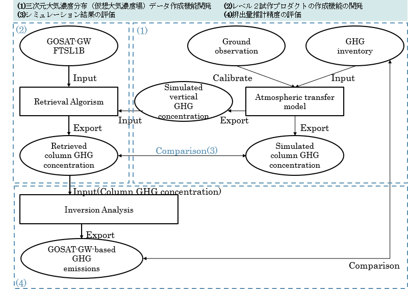
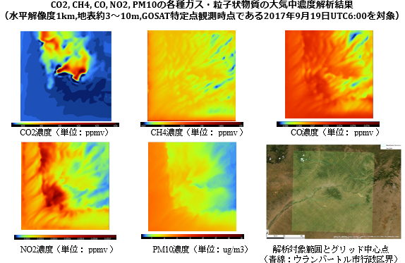
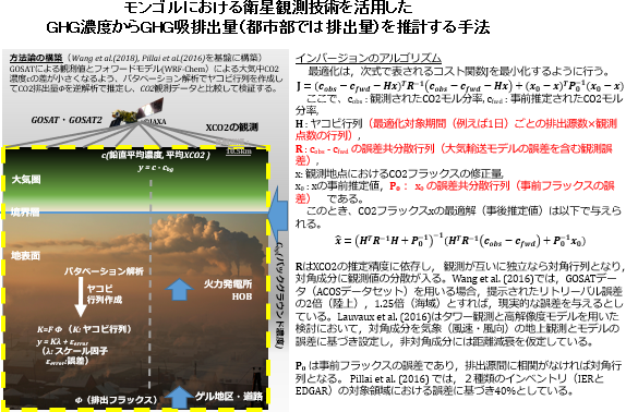
To date, the National Institute for Environmental Studies (NIES), in collaboration with the Ministry of the Environment and the Japan Aerospace Exploration Agency (JAXA), has developed the world’s first dedicated greenhouse gas observation satellite, the Greenhouse gases Observing Satellite “IBUKI” (GOSAT). Launched in 2009, IBUKI has continued to observe beyond its expected lifespan of 5 years, now surpassing 11 years. The data collected has revealed increasing global concentrations and distribution changes of major greenhouse gases, such as carbon dioxide and methane, even with seasonal fluctuations. This crucial information is disseminated worldwide by NIES.

Given the unabating rise in greenhouse gas concentrations, the Ministry of the Environment, NIES, and JAXA developed GOSAT-2, a successor to GOSAT, to continue its mission and contribute to understanding the effectiveness of international greenhouse gas emissions reduction policies aimed at achieving the goals of the Paris Agreement. GOSAT-2 was launched in October 2018 and began regular operations in February 2019, with product distribution to the public starting in August 2019. There is international demand for continued global greenhouse gas observation beyond GOSAT-2’s designed lifespan of 5 years.

Development Background

In this context, NIES and the Ministry of the Environment have begun designing the third-generation Greenhouse Gas Observing Sensor (TANSO-3) since 2018, leveraging the expertise gained from GOSAT and GOSAT-2. TANSO-3 aims to improve the identification and estimation accuracy of greenhouse gas emissions sources, in line with Japan’s Basic Space Plan and the associated timeline decided in December 2019.

Meanwhile, the satellite set to carry TANSO-3, the third Greenhouse Gas Observing Technology Satellite, will also host the Advanced Microwave Scanning Radiometer 3 (AMSR3), succeeding the microwave radiometer on the Global Change Observation Mission – Water (GCOM-W). This dual-purpose satellite, GOSAT-GW, is being developed for a planned launch in the fiscal year 2021 to continue the missions of GOSAT and GOSAT-2 and enhance monitoring of large-scale emission sources and transparency in GHG inventory reporting under the Paris Agreement.

Project Objectives

The project aims to develop a TANSO-3 simulator that can evaluate the anticipated concentration measurement performance of TANSO-3’s prototype (development model) through its design, manufacturing, and testing stages. This simulator will also be used in the design and manufacturing phases of the actual sensor and related systems, as well as in evaluating sensor performance after the launch of GOSAT-GW

  • Furthermore, the project will develop a feature to create three-dimensional atmospheric concentration distribution datasets (virtual atmospheric concentration fields) and streamline the process by maximizing the use of the results from the “Evaluation of Greenhouse Gas Emission Estimation Accuracy for Mongolia Using the GOSAT Series.”
  • It involves prototyping Level 2 products from Level 1 prototype products created by NIES and comparing the simulated results of CO2, CH4, and NO2 column concentrations with the three-dimensional atmospheric concentration distribution data.
  • Lastly, it will estimate anthropogenic greenhouse gas emissions (assuming CO2 and CH4) based on the Level 2 prototype products obtained from simulation results and evaluate these against the greenhouse gas emissions used in creating the three-dimensional atmospheric concentration distribution.

Overview of Methods for Estimating Level 2 Products and Greenhouse Gas Emission Amounts in This Project

本事業における L2プロダクト相当の推定方法及び温室効果ガスの排出量推計方法の概要

Development of Three-Dimensional Atmospheric Concentration Distribution Data Creation Function

We will develop a function to calculate and create datasets of three-dimensional atmospheric concentration distribution (virtual atmospheric concentration fields). The forward analysis model was constructed based on a configuration that includes the main modules related to methane from WRF-Chem V4.

  • Considerations include emissions from wetlands, soil uptake, and termite emissions.
  • Emissions from permafrost are not included.
  1. The target gas components include CO2, CH4, CO, NO2, and aerosols such as PM10.
  2. The target regions are Mongolia and the city of Ulaanbaatar, with a horizontal resolution of 9 km for calculations across Mongolia and 1 km for those within Ulaanbaatar.
  3. The number of vertical layers is 35 for CO2 calculations and 34 for other gases, leading to four model configurations: A) Mongolia-wide CO2, B) Mongolia-wide non-CO2 gases, C) Ulaanbaatar city CO2, and D) Ulaanbaatar city non-CO2 gases.

Main Methane-Related Modules in WRF-Chem V4

Development of Level 2 Prototype Product Creation Function

Using Level 1 prototype products created by NIES as input, we have prototyped Level 2 products.

Retrieval Processing Environment Setup

The focused wavelength bands and absorbing gas species considered in the forward calculation are as follows. Common conditions for both forward and retrieval calculations were established.

Forward Model Construction

A forward model was constructed to calculate the radiance spectrum and the Jacobian matrix of the state vector using the FTSL1B product, assumed for GOSAT-GW, as the input for the Level 1 prototype product.

Inverse Model Construction

An inverse model was constructed to back-calculate column concentrations of CO2, CH4, NO2, etc., from the radiance spectrum and the Jacobian matrix. The construction incorporated retrieval processing functionality added to the forward model using SCIATRAN, with the OCO-2 Level 2 Full Physics Retrieval Algorithm from the Jet Propulsion Laboratory serving as a reference.

Column Concentration Calculation

Column concentrations of CO2, CH4, NO2, etc., were estimated for GOSAT-GW-assumed L1B products near Ulaanbaatar, Mongolia. Initial retrieval calculations were performed for test case locations on September 19, 2017, successfully reproducing average column concentrations of each ミゅレーション結果の評価Simulation Results Evaluation

Simulation Results Evaluation

The three-dimensional atmospheric concentration distribution data obtained from the “Development of Three-Dimensional Atmospheric Concentration Distribution Data Creation Function” were used as truth values to compare and evaluate the simulated column concentrations of CO2, CH4, NO2 obtained from the “Development of Level 2 Prototype Product Creation Function.”

Emission Estimation Accuracy Evaluation

Based on the Level 2 prototype products obtained from “Simulation Results Evaluation,” we estimated anthropogenic greenhouse gas emissions (assuming CO2 and CH4) and compared these estimates with greenhouse gas emissions used in creating the three-dimensional atmospheric concentration distribution from the “Development of Three-Dimensional Atmospheric Concentration Distribution Data Creation Function.”

Main Results

  1. An algorithm was constructed for retrieval processing using the radiance spectra from the TANSO-3 simulator as input for the Level 1 prototype products.
  2. Using this algorithm, we calculated the column concentrations of CO2 (XCO2), CH4 (XCH4), and NO2 (XNO2). Upon comparing the retrieval results with the three-dimensional atmospheric concentration distribution model analysis results, the differences in absolute values for XCO2, XCH4, and XNO2 at a 9 km resolution were 1.04–1.17 ppm for XCO2, 0.0021–0.0546 ppm for XCH4, and 0.0000293–0.0000442 ppm for XNO2. For a 1 km resolution, the differences were 0.46–0.51 ppm for XCO2, 0.0760–0.142 ppm for XCH4, and 0.0000018–0.0000025 ppm for XNO2.
  3. A Green’s function inverse analysis for CO2 using the calculated XCO2 concentration values was conducted to compare with the CO2 inventory. As a result, for a 9 km resolution, the 2017 GHG emission inventory (estimated values for this project) was within about -3.0% to +4.6% compared to the true values, and for a 1 km resolution, it was within -1.5% to +2.9%. This error range demonstrates the expected discrepancies when setting the observational error for XCO2 by GOSAT at 4.0 (ppmv) and the emission error at 400 (ton/h).